Another Sunday walk between the Botrange & Baheyon Valley
At the edge of the fens (still extremely dry ) and the woods of Ovifat / Longfaye, Jan had found a recommended walk so we had to go and try it.
At the start of our walk all trails were really deserted as if the news of the fire last week has convinced all tourists that there's no nature left to enjoy here. It was absolutely fantastic to be out there on our own.
At the edge of the woods there were regular large fire cuts or small open areas with more peat lands. With the wind in our faces and the absence of other humans nearby we both hoped to spot some wildlife and we unconciously walked really quietly looking around.
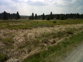
All of a sudden Jan pulls my sleeve heavily both signalling me to be absolutely quiet and pointing me a deer just ahead of us on the road, staring surprised into our eyes for a second before it went off. We both grabbed our mobiles to turn on the camera function while we tiptoed further on the road hoping in vain that the deer would take another pauze just a few meters further, allowing us some picture opportunities. Sorry, you'll have to settle with the road itself :)

The rest of the walk led us through a gorgeous valley of the little river Baheyon . I must say that Belgian waterfalls in an extremely dry season look very pathetic, but pathetic is not the word to use for the valley though. Unfortunately rivers run downhill ....so we had to do a lot of climbing back up at the end. Someone was pretty tired and very happy to see the car at the end ;-)


At the start of our walk all trails were really deserted as if the news of the fire last week has convinced all tourists that there's no nature left to enjoy here. It was absolutely fantastic to be out there on our own.

At the edge of the woods there were regular large fire cuts or small open areas with more peat lands. With the wind in our faces and the absence of other humans nearby we both hoped to spot some wildlife and we unconciously walked really quietly looking around.
All of a sudden Jan pulls my sleeve heavily both signalling me to be absolutely quiet and pointing me a deer just ahead of us on the road, staring surprised into our eyes for a second before it went off. We both grabbed our mobiles to turn on the camera function while we tiptoed further on the road hoping in vain that the deer would take another pauze just a few meters further, allowing us some picture opportunities. Sorry, you'll have to settle with the road itself :)

The rest of the walk led us through a gorgeous valley of the little river Baheyon . I must say that Belgian waterfalls in an extremely dry season look very pathetic, but pathetic is not the word to use for the valley though. Unfortunately rivers run downhill ....so we had to do a lot of climbing back up at the end. Someone was pretty tired and very happy to see the car at the end ;-)


Comments
Maar als je ooit specifiekere info wil of een lokale gids of zo, moet je het maar laten weten. Ikzelf ben dus deeltijds in Leuven of ginder :)
@Virtual Sprite: I do too :)